Reader small image

You're reading from  Learning ArcGIS Geodatabases

Product typeBook
Published inJun 2014
Publisher
ISBN-139781783988648
Edition1st Edition
Right arrow
Author (1)
Hussein Nasser
Hussein Nasser
author image
Hussein Nasser

Hussein Nasser is an Esri award-winning senior GIS solution architect working in the GIS field since 2006. He is the author of three books in the ArcGIS technology: Administering ArcGIS for Server, Learning ArcGIS Geodatabases, and Building Web Applications with ArcGIS, all by Packt Publishing. In 2007, he won the first place at the annual ArcGIS Server Code Challenge, conducted at the Esri Developer Summit in Palm Springs, California. In 2014, he started the IGeometry YouTube channel, where he periodically publishes educational GIS videos.
Read more about Hussein Nasser

Right arrow

Using the model builder


Besides Python scripting, the model builder is a nice way to aggregate multiple geoprocessing tools without the need to have programming skills. If you found it difficult to write Python scripts, you can always use the model builder to create interesting models. In this section, we will use the model builder to build a sample model to create a file geodatabase and a feature class.

Creating a model

You can create a model from either ArcMap or ArcCatalog. To create a model, perform the following steps:

  1. Create a folder in the c:\gdb folder and name it myTools.

  2. Open ArcCatalog, point the cursor to the Geoprocessing menu, and then click on ModelBuilder.

    Note

    You can also use ArcMap to work with ArcToolbox.

  3. Bring up the ArcToolbox window as well since we will use both. Keep both windows next to each other.

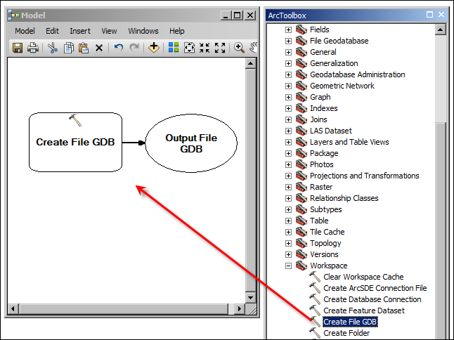
  4. In the ArcToolbox window, expand Data Management Tools and Workspace, and then drag the Create File GDB tool to the Model window as illustrated in the following screenshot:

The...

lock icon
The rest of the page is locked
Previous PageNext Page
You have been reading a chapter from
Learning ArcGIS Geodatabases
Published in: Jun 2014Publisher: ISBN-13: 9781783988648

Author (1)

author image
Hussein Nasser

Hussein Nasser is an Esri award-winning senior GIS solution architect working in the GIS field since 2006. He is the author of three books in the ArcGIS technology: Administering ArcGIS for Server, Learning ArcGIS Geodatabases, and Building Web Applications with ArcGIS, all by Packt Publishing. In 2007, he won the first place at the annual ArcGIS Server Code Challenge, conducted at the Esri Developer Summit in Palm Springs, California. In 2014, he started the IGeometry YouTube channel, where he periodically publishes educational GIS videos.
Read more about Hussein Nasser