Reader small image

You're reading from  Learning ArcGIS Geodatabases

Product typeBook
Published inJun 2014
Publisher
ISBN-139781783988648
Edition1st Edition
Right arrow
Author (1)
Hussein Nasser
Hussein Nasser
author image
Hussein Nasser

Hussein Nasser is an Esri award-winning senior GIS solution architect working in the GIS field since 2006. He is the author of three books in the ArcGIS technology: Administering ArcGIS for Server, Learning ArcGIS Geodatabases, and Building Web Applications with ArcGIS, all by Packt Publishing. In 2007, he won the first place at the annual ArcGIS Server Code Challenge, conducted at the Esri Developer Summit in Palm Springs, California. In 2014, he started the IGeometry YouTube channel, where he periodically publishes educational GIS videos.
Read more about Hussein Nasser

Right arrow

Chapter 3. Modeling Geodatabases

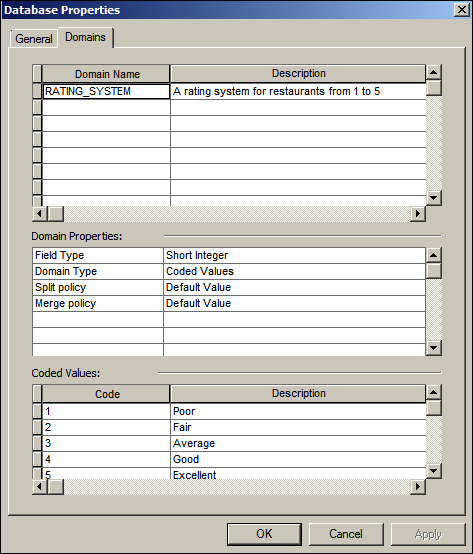
In the previous chapter, we managed to complete a geodatabase, create feature classes, add attributes, work with domains, and so much more. However, it was a quick and rough design, not very efficient. We also had multiple feature classes which are almost identical. They have some differences, but they share a lot of attributes. You may imagine that if I ask you to delete an attribute in your geodatabase or change its size, you will have to do it in all these feature classes. We had to repeat a lot of steps and duplicate fields between the different feature classes, and that is because we didn't spend time on designing a proper model for our geodatabase.

Modeling geodatabases is important; it allows you to identify the weak points in your geodatabase design before implementing it physically. The moment you commit to a design and start populating your geodatabase, it becomes expensive to modify the schema. In this chapter, we will work on remodeling the Bestaurant...

The entity relationship diagram for Bestaurants


A consultant was hired for the Bestaurants project to advise on the newly created geodatabase. After taking a look at the geodatabase, the consultant found it a bit difficult to assess the design by looking at the physical geodatabase. So, she suggested that we create an entity relationship diagram in order to visualize the design better and find the bottlenecks, if any.

The flaws in the current geodatabase

We will start by laying out the current entity relationship diagram as the consultant suggested. This way, we can identify the inefficiencies and flaws in the current model. There are a lot of tools available that enable you to do database modeling such as Microsoft Visio and ArcgoUML. I'm using an online tool called Gliffy for designing and modeling geodatabases. You can access it for free without creating an account at www.gliffy.com. You don't have to do the modeling part in this chapter; however, it is recommended that you model your design...

Implementing the proposed model


We have a new model, so we need to create a new geodatabase. Let's keep our existing Bestaurants geodatabase and call the new one Bestaurants_new.

Authoring the geodatabase

To create the geodatabase, open ArcCatalog, browse to c:\gdb, and create a Bestaurants_new file geodatabase (refer to Chapter 1, Authoring Geodatabases, in case you have forgot how to do this). We need to create the RATING_SYSTEM domain. Right-click on the new geodatabase and select Properties, and then activate the Domain tab. We have done this previously in Chapter 2, Working with Geodatabase Datasets. The following screenshot will remind you how to create the domain:

Creating geodatabase datasets

Next, we need to create the Food_and_Drinks feature class and then create the relationship. Right-click on the Bestaurants_new geodatabase, point the cursor to New, and then select Feature Class. Name it Food_and_Drinks. Put a proper readable alias name; make sure that it is a point geometry and...

Testing the new geodatabase in ArcMap


Our new geodatabase is ready; it is time to put it to the test. Open Belize_Basemap_new.mxd. You can find it in the supporting files for this chapter, 8648OT_03_Files, which can be downloaded from www.packtpub.com. Add the Food_and_Drinks feature class and set a proper symbology for each subtype, as we learned in Chapter 2, Working with Geodatabase Datasets. Start editing; let's add a lounge next to Water Lane street. If you can't find Water Lane street on the map, you can add it anywhere. Populate the new feature with the following attributes and any two reviews as shown in the following screenshot (refer to the Working with object tables and relations section of Chapter 2, Working with Geodatabase Datasets, to learn how to create related tables):

Now, it's time to test our new attachment option by adding a picture to our Water Lane Lounge. Can you see an attachment icon of a paperclip in the previous screenshot? Click on it to open Attachment Manager...

Summary


In this chapter, you learned how to model the geodatabase. Using your newly acquired skills, you redesigned your model and simplified your geodatabase. You learned how to enable attachments on a feature class in order to allow attaching files for individual features. You also added new subtypes, reassigned the domains, and tested all this by the end of the chapter. In the next chapter, we will take the geodatabase to the next level by optimizing it to run effectively.

lock icon
The rest of the chapter is locked
You have been reading a chapter from
Learning ArcGIS Geodatabases
Published in: Jun 2014Publisher: ISBN-13: 9781783988648
Register for a free Packt account to unlock a world of extra content!
A free Packt account unlocks extra newsletters, articles, discounted offers, and much more. Start advancing your knowledge today.
undefined
Unlock this book and the full library FREE for 7 days
Get unlimited access to 7000+ expert-authored eBooks and videos courses covering every tech area you can think of
Renews at $15.99/month. Cancel anytime

Author (1)

author image
Hussein Nasser

Hussein Nasser is an Esri award-winning senior GIS solution architect working in the GIS field since 2006. He is the author of three books in the ArcGIS technology: Administering ArcGIS for Server, Learning ArcGIS Geodatabases, and Building Web Applications with ArcGIS, all by Packt Publishing. In 2007, he won the first place at the annual ArcGIS Server Code Challenge, conducted at the Esri Developer Summit in Palm Springs, California. In 2014, he started the IGeometry YouTube channel, where he periodically publishes educational GIS videos.
Read more about Hussein Nasser