Reader small image

You're reading from  Learning ArcGIS Geodatabases

Product typeBook
Published inJun 2014
Publisher
ISBN-139781783988648
Edition1st Edition
Right arrow
Author (1)
Hussein Nasser
Hussein Nasser
author image
Hussein Nasser

Hussein Nasser is an Esri award-winning senior GIS solution architect working in the GIS field since 2006. He is the author of three books in the ArcGIS technology: Administering ArcGIS for Server, Learning ArcGIS Geodatabases, and Building Web Applications with ArcGIS, all by Packt Publishing. In 2007, he won the first place at the annual ArcGIS Server Code Challenge, conducted at the Esri Developer Summit in Palm Springs, California. In 2014, he started the IGeometry YouTube channel, where he periodically publishes educational GIS videos.
Read more about Hussein Nasser

Right arrow

Testing the new geodatabase in ArcMap


Our new geodatabase is ready; it is time to put it to the test. Open Belize_Basemap_new.mxd. You can find it in the supporting files for this chapter, 8648OT_03_Files, which can be downloaded from www.packtpub.com. Add the Food_and_Drinks feature class and set a proper symbology for each subtype, as we learned in Chapter 2, Working with Geodatabase Datasets. Start editing; let's add a lounge next to Water Lane street. If you can't find Water Lane street on the map, you can add it anywhere. Populate the new feature with the following attributes and any two reviews as shown in the following screenshot (refer to the Working with object tables and relations section of Chapter 2, Working with Geodatabase Datasets, to learn how to create related tables):

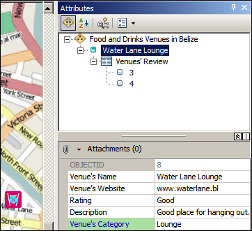
Now, it's time to test our new attachment option by adding a picture to our Water Lane Lounge. Can you see an attachment icon of a paperclip in the previous screenshot? Click on it to open Attachment Manager...

lock icon
The rest of the page is locked
Previous PageNext Page
You have been reading a chapter from
Learning ArcGIS Geodatabases
Published in: Jun 2014Publisher: ISBN-13: 9781783988648

Author (1)

author image
Hussein Nasser

Hussein Nasser is an Esri award-winning senior GIS solution architect working in the GIS field since 2006. He is the author of three books in the ArcGIS technology: Administering ArcGIS for Server, Learning ArcGIS Geodatabases, and Building Web Applications with ArcGIS, all by Packt Publishing. In 2007, he won the first place at the annual ArcGIS Server Code Challenge, conducted at the Esri Developer Summit in Palm Springs, California. In 2014, he started the IGeometry YouTube channel, where he periodically publishes educational GIS videos.
Read more about Hussein Nasser