Reader small image

You're reading from  ArcGIS for Desktop Cookbook

Product typeBook
Published inJan 2015
Reading LevelBeginner
Publisher
ISBN-139781783559503
Edition1st Edition
Languages
Tools
Right arrow
Author (1)
Daniela C Docan
Daniela C Docan
author image
Daniela C Docan

Daniela Cristiana Docan is currently a lecturer at the Department of Topography and Cadastre at the Faculty of Geodesy in Bucharest, Romania. She obtained her PhD in 2009 from the Technical University of Civil Engineering, Bucharest, with her thesis Contributions to quality improvement of spatial data in GIS. Formerly, she worked at Esri Romania and National Agency for Cadastre and Land Registration (ANCPI). While working for Esri Romania, she trained teams (as an authorized instructor in ArcGIS for Desktop by Esri) from state- and privately-owned companies, such as the Romanian Aeronautical Authority, the Agency of Payments and Intervention for Agriculture (APIA), and the Institute of Hydroelectric Studies and Design. She also trained and assisted the team in charge of quality data control in the Land Parcel Identification System (LPIS) project, in Romania. For the ANCPI, she created the logical and physical data model for the Romanian National Topographic Dataset at a scale of 1:5,000 (TOPRO5) in 2009. She was a member of the workgroup that elaborated TOPRO5 and its metadata technical specifications and the Report on the implementation of the INSPIRE Directive in Romania in 2010. Prior to this book, Daniela worked on ArcGIS for Desktop Cookbook, Packt Publishing, which covers the following topics: designing a file geodatabase schema, constraining the geometry and attribute values of the data, geocoding addresses, working with routes and events, and using spatial ETL tools.
Read more about Daniela C Docan

Right arrow

Importing data from the XML format


An XML file can transport and store geodatabase schema and spatial data. Geodatabase XML is Esri's XML-based interchange format used to share data (workspace data) and geodatabase schema in full or in part (workspace definition) between geodatabases or other software systems.

Getting ready

In this recipe, you will create a file geodatabase schema by importing an XML workspace document that contains only the workspace definition as shown in the following screenshot:

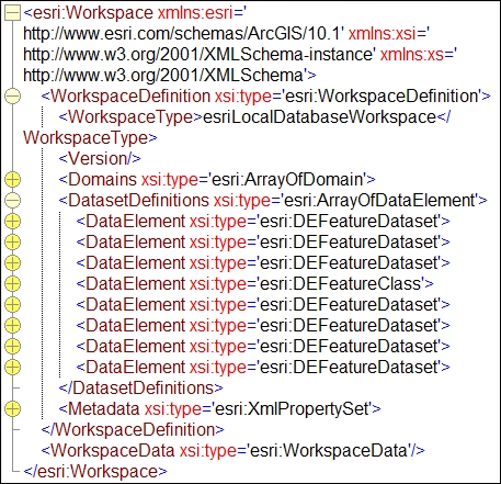
You will use the TOPO5000.XML file created in the previous exercise.

How to do it...

Follow these steps to create a file geodatabase using as a template an ArcGIS XML workspace document:

  1. In Catalog Tree, go to Interoperability\MyResults. Right-click on the MyResults folder and navigate to New | New File Geodatabase. Rename New File Geodatabase.gdb to MyTOPO.

  2. Right-click on TOPO5000.gdb and navigate to Import | XML Workspace Document. Check Schema Only and specify the XML source to import by selecting...

lock icon
The rest of the page is locked
Previous PageNext Page
You have been reading a chapter from
ArcGIS for Desktop Cookbook
Published in: Jan 2015Publisher: ISBN-13: 9781783559503

Author (1)

author image
Daniela C Docan

Daniela Cristiana Docan is currently a lecturer at the Department of Topography and Cadastre at the Faculty of Geodesy in Bucharest, Romania. She obtained her PhD in 2009 from the Technical University of Civil Engineering, Bucharest, with her thesis Contributions to quality improvement of spatial data in GIS. Formerly, she worked at Esri Romania and National Agency for Cadastre and Land Registration (ANCPI). While working for Esri Romania, she trained teams (as an authorized instructor in ArcGIS for Desktop by Esri) from state- and privately-owned companies, such as the Romanian Aeronautical Authority, the Agency of Payments and Intervention for Agriculture (APIA), and the Institute of Hydroelectric Studies and Design. She also trained and assisted the team in charge of quality data control in the Land Parcel Identification System (LPIS) project, in Romania. For the ANCPI, she created the logical and physical data model for the Romanian National Topographic Dataset at a scale of 1:5,000 (TOPRO5) in 2009. She was a member of the workgroup that elaborated TOPRO5 and its metadata technical specifications and the Report on the implementation of the INSPIRE Directive in Romania in 2010. Prior to this book, Daniela worked on ArcGIS for Desktop Cookbook, Packt Publishing, which covers the following topics: designing a file geodatabase schema, constraining the geometry and attribute values of the data, geocoding addresses, working with routes and events, and using spatial ETL tools.
Read more about Daniela C Docan