


Importing and exporting data with the ogr2ogr GDAL command
In this recipe, you will use the popular ogr2ogr GDAL command for importing and exporting vector data from PostGIS.
Firstly, you will import a shapefile in PostGIS using the most significant options of the ogr2ogr command. Then, still using ogr2ogr, you will export the results of a spatial query performed in PostGIS to a couple of GDAL-supported vector formats.
How to do it...
The steps you need to follow to complete this recipe are as follows:
- Unzip the
wborders.ziparchive to your working directory. You can find this archive in the book's dataset. - Import the world countries shapefile (
wborders.shp) in PostGIS using theogr2ogrcommand. Using some of the options fromogr2ogr, you will import only the features fromSUBREGION=2(Africa), and theISO2andNAMEattributes, and rename the feature class toafrica_countries:
      $ ogr2ogr -f PostgreSQL -sql "SELECT ISO2,
      NAME AS country_name FROM wborders WHERE REGION=2" -nlt
      MULTIPOLYGON PG:"dbname='postgis_cookbook' user='me'
      password='mypassword'" -nln africa_countries
-lco SCHEMA=chp01 -lco GEOMETRY_NAME=the_geom wborders.shp- Check if the shapefile was correctly imported in PostGIS, querying the spatial table in the database or displaying it in a desktop GIS.
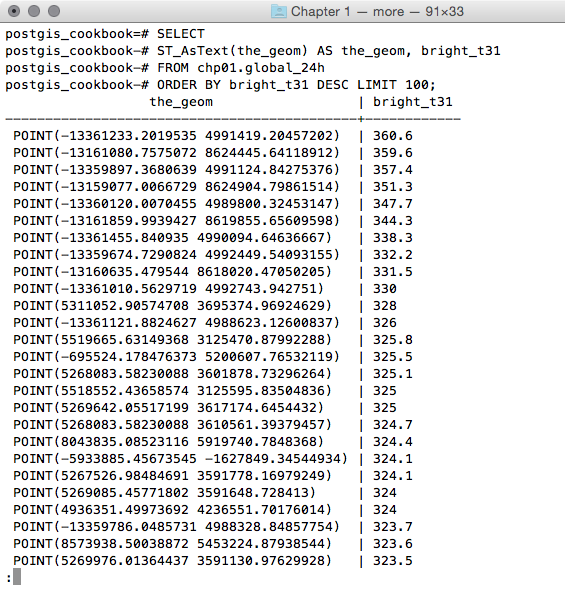
- Query PostGIS to get a list of the 100 active hotspots with the highest brightness temperature (the
bright_t31field) from theglobal_24htable created in the previous recipe:
      postgis_cookbook=# SELECTST_AsText(the_geom) AS the_geom, bright_t31
FROM chp01.global_24h
ORDER BY bright_t31 DESC LIMIT 100;
The output of the preceding command is as follows:
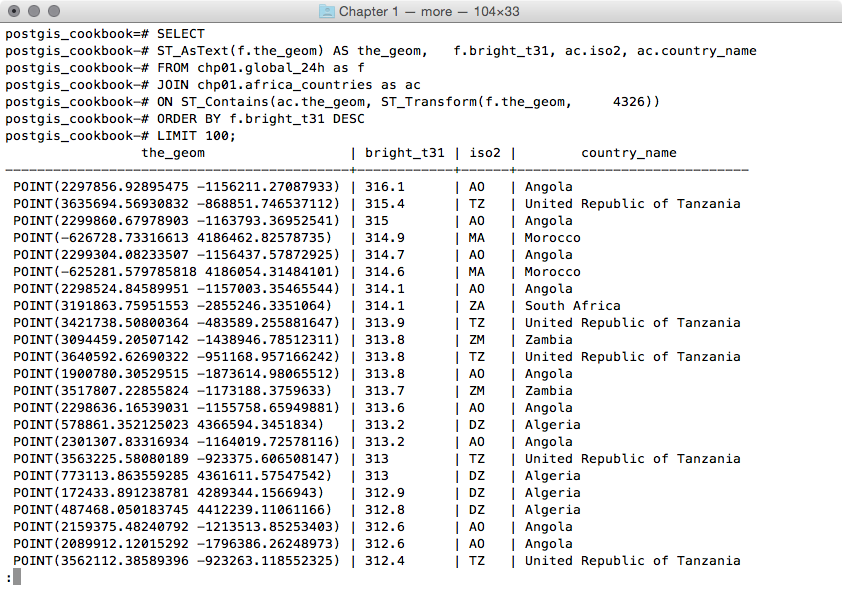
- You want to figure out in which African countries these hotspots are located. For this purpose, you can do a spatial join with the
africa_countriestable produced in the previous step:
      postgis_cookbook=# SELECT ST_AsText(f.the_geom)
      AS the_geom, f.bright_t31, ac.iso2, ac.country_name
      FROM chp01.global_24h as f
      JOIN chp01.africa_countries as ac
      ON ST_Contains(ac.the_geom, ST_Transform(f.the_geom, 4326))
      ORDER BY f.bright_t31 DESCLIMIT 100;
The output of the preceding command is as follows:
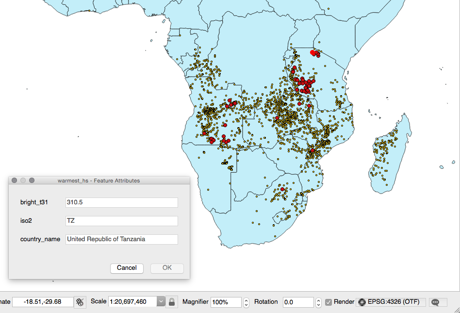
You will now export the result of this query to a vector format supported by GDAL, such as GeoJSON, in the WGS 84 spatial reference using ogr2ogr:
      $ ogr2ogr -f GeoJSON -t_srs EPSG:4326 warmest_hs.geojson
      PG:"dbname='postgis_cookbook' user='me' password='mypassword'" -sql "
      SELECT f.the_geom as the_geom, f.bright_t31,
             ac.iso2, ac.country_name
      FROM chp01.global_24h as f JOIN chp01.africa_countries as ac
      ON ST_Contains(ac.the_geom, ST_Transform(f.the_geom, 4326))
ORDER BY f.bright_t31 DESC LIMIT 100"- Open the GeoJSON file and inspect it with your favorite desktop GIS. The following screenshot shows you how it looks with QGIS:
- Export the previous query to a CSV file. In this case, you have to indicate how the geometric information must be stored in the file; this is done using the
-lco GEOMETRYoption:
      $ ogr2ogr -t_srs EPSG:4326 -f CSV -lco GEOMETRY=AS_XY
      -lco SEPARATOR=TAB warmest_hs.csv PG:"dbname='postgis_cookbook'
       user='me' password='mypassword'" -sql "
       SELECT f.the_geom, f.bright_t31,
         ac.iso2, ac.country_name
       FROM chp01.global_24h as f JOIN chp01.africa_countries as ac
       ON ST_Contains(ac.the_geom, ST_Transform(f.the_geom, 4326))
       ORDER BY f.bright_t31 DESC  LIMIT 100"
How it works...
GDAL is an open source library that comes together with several command-line utilities, which let the user translate and process raster and vector geodatasets into a plethora of formats. In the case of vector datasets, there is a GDAL sublibrary for managing vector datasets named OGR (therefore, when talking about vector datasets in the context of GDAL, we can also use the expression OGR dataset).
When you are working with an OGR dataset, two of the most popular OGR commands are ogrinfo, which lists many kinds of information from an OGR dataset, and ogr2ogr, which converts the OGR dataset from one format to another.
It is possible to retrieve a list of the supported OGR vector formats using the -formats option on any OGR commands, for example, with ogr2ogr:
$ ogr2ogr --formatsThe output of the preceding command is as follows:
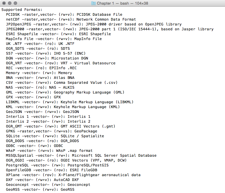
Note that some formats are read-only, while others are read/write.
PostGIS is one of the supported read/write OGR formats, so it is possible to use the OGR API or any OGR commands (such as ogrinfo and ogr2ogr) to manipulate its datasets.
The ogr2ogr command has many options and parameters; in this recipe, you have seen some of the most notable ones such as -f to define the output format, -t_srs to reproject/transform the dataset, and -sql to define an (eventually spatial) query in the input OGR dataset.
When using ogrinfo and ogr2ogr together with the desired option and parameters, you have to define the datasets. When specifying a PostGIS dataset, you need a connection string that is defined as follows:
PG:"dbname='postgis_cookbook' user='me' password='mypassword'"See also
You can find more information about the ogrinfo and ogr2ogr commands on the GDAL website available at http://www.gdal.org.
If you need more information about the PostGIS driver, you should check its related documentation page available at http://www.gdal.org/drv_pg.html.


