Search icon
Subscription
0
Cart icon
Close icon
You have no products in your basket yet
Arrow left icon
All Products
Best Sellers
New Releases
Books
Videos
Audiobooks
Learning Hub
Newsletters
Free Learning
Arrow right icon
Applying and Extending Oracle Spatial

You're reading from  Applying and Extending Oracle Spatial

Product type Book
Published in Sep 2013
Publisher Packt
ISBN-13 9781849686365
Pages 568 pages
Edition 1st Edition
Languages

Table of Contents (20) Chapters

Applying and Extending Oracle Spatial
Credits
About the Authors
About the Reviewers
www.PacktPub.com
Preface
1. Defining a Data Model for Spatial Data Storage 2. Importing and Exporting Spatial Data 3. Using Database Features in Spatial Applications 4. Replicating Geometries 5. Partitioning of Data Using Spatial Keys 6. Implementing New Functions 7. Editing, Transforming, and Constructing Geometries 8. Using and Imitating Linear Referencing Functions 9. Raster Analysis with GeoRaster 10. Integrating Java Technologies with Oracle Spatial 11. SQL/MM – A Basis for Cross-platform, Inter-operable, and Reusable SQL Table Comparing Simple Feature Access/SQL and SQL/MM–Spatial
Use of TREAT and IS OF TYPE with ST_GEOMETRY Index

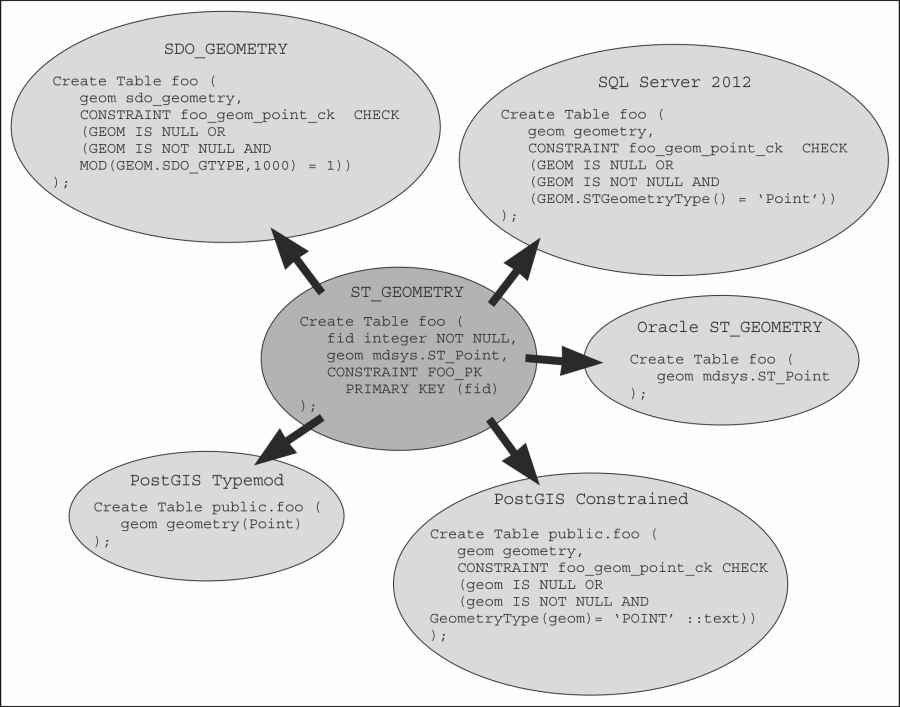
Geometry type implementation matrix


From what we have learned so far, a table/column implementation matrix can be produced that will allow us to implement all possible variations of the SQL/MM Spatial standard. In the following diagram, the matrix is implemented only for the ST_POINT subtype. However, included with this book are a set of SQL files that provide an implementation of the standard's ST_* geometry types. No Primary Key attribute and constraint text is included for brevity's sake in any of the implementations shown in the following diagram:

Because some Oracle geometry subtypes (CircularString) can only be identified by functions that cannot be used by CHECK constraints (such as Get_WKT), a trigger must be constructed to implement the constraint:

Create Or Replace Trigger st_road_circularstring_biu 
Before Insert or update on ST_ROAD 
Referencing old As old new As new 
For Each Row
Begin
  If (:new.GEOM IS NULL) Then
     Return;
  End If;
  If (:new.GEOM IS NOT NULL And 
    ...
lock icon The rest of the chapter is locked
Register for a free Packt account to unlock a world of extra content!
A free Packt account unlocks extra newsletters, articles, discounted offers, and much more. Start advancing your knowledge today.
Unlock this book and the full library FREE for 7 days
Get unlimited access to 7000+ expert-authored eBooks and videos courses covering every tech area you can think of
Renews at €14.99/month. Cancel anytime}